A reading companion and a reusable dataset need different checks
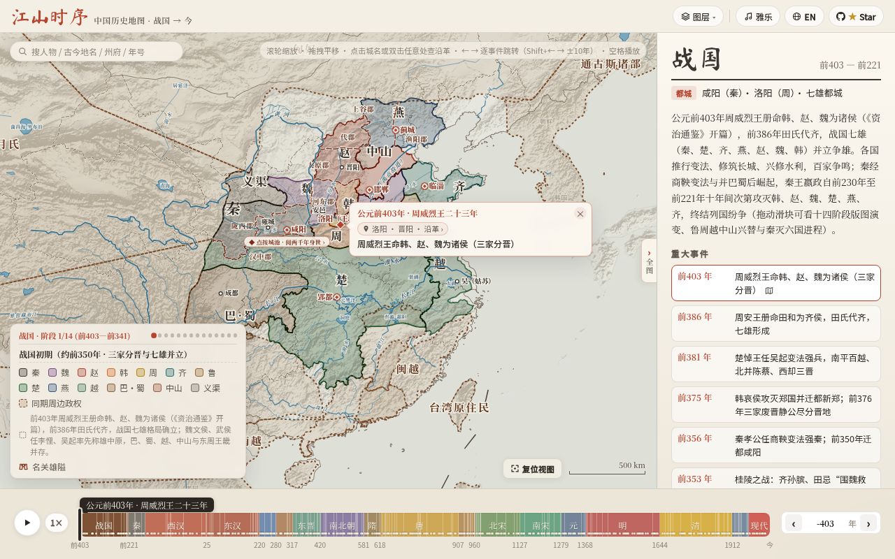
An old place name in a poem gives you a concrete starting point for evaluating Chronicles of the Realm, the project named jiangshan-map. Its README describes Trace Place cards for following changes in a place's name and administrative jurisdiction, plus Person Chronicle routes for figures such as Su Shi. English documentation and an English interface are documented.
That makes it a candidate for readers and teachers seeking geographic context. Reusing its geometry requires a separate decision: the README specifies approximate borders, exceptions to GPL-3.0 licensing and an export cutoff. Those limits matter before a developer adapts the data for another product.
What our assessment could verify
We did not run jiangshan-map. On October 23, 2026, the harness recorded commit 5e940f6 and reported no supported ecosystem for this JavaScript repository and no Dockerfile. This establishes a limit of the harness assessment, not a product failure. There are no installation, build, test or audit results.
The recorded sandbox had 3 CPUs and 8 GB RAM, with no image identified. It provides no evidence about rendering speed, mobile behavior or browser requirements. Actual runtime and operating-system versions are unknown.
The supplied README extracts are not pinned to that commit. This review therefore separates the recorded checkout assessment from the repository's documented workflows; it does not establish that every documented feature exists or works at commit 5e940f6.
Check one place before planning a lesson
The README documents cloning the repository, serving it with Python's HTTP server and opening the page in a browser. It also documents shareable year-and-place links and the English option lang=en. None of those browser steps was reproduced here.
For a lesson, start with one location from the assigned text. Check the selected year, place-name interpretation and displayed jurisdiction against the lesson's sources, then open the link on the intended classroom device. This is a suggested evaluation procedure, not an exercise conducted for this review.
Schematic borders need their qualification
The atlas describes its historical borders as schematic approximations. Its credits explain that the territorial contours and prefecture boundaries illustrate broad historical jurisdictions rather than modern surveyed borders.
Keep that qualification with any screenshot or exported layer. A reader seeking geographic context may find a broad outline useful; a researcher making a precise jurisdiction claim needs to inspect the relevant historical evidence. The README's credits identify references, but this assessment does not independently validate their use for individual places and years.
Some layers retain non-commercial terms
The README says prefecture-level boundaries and Warring States territories derived from CHGIS V6 and the Hartwell China Historical GIS retain their original academic, non-commercial terms and are not relicensed under GPL-3.0.
A commercial developer should resolve the terms for the intended layer before incorporating it into a product. The repository's GPL-3.0 label does not settle permissions for those exceptions. This review has not audited the licensing chain or determined whether a particular reuse is permitted.
GeoJSON export stops at 1948
The documented GeoJSON export covers 403 BCE through 1948 and excludes later years and the modern province layer. The interface's advertised coverage through the present should therefore not be read as the export's coverage.
Check the required years and layers before adapting the output. If the project needs modern provincial polygons, this documented export does not supply them. Export generation and downstream use were not tested here.
Alternatives depend on the work you need to do
QGIS supports spatial-data editing and georeferencing. Consider it when you need a GIS workspace to assemble and inspect your own geographic evidence. You still need suitable source data and permission to use it.
historical-basemaps provides historical boundary data intended for world or continental mapping. Its README asks users to compare the maps with other sources before academic use. Consider it for broader geographic datasets, while checking its coverage and precision for your project. Jiangshan-map credits this project, so the relationship does not provide independent corroboration of accuracy.
Repository activity does not establish accuracy
The supplied repository metadata records a push on October 23, 2026. The supplied release record dates v1.0.0 to October 17, 2026. These establish repository activity, without showing what the later push corrected or how accurately the atlas represents historical geography. The assessed checkout remains commit 5e940f6; it is not identified here as the v1.0.0 release checkout.
How the documentation rating works
Documentation receives 4 out of 5 for the supplied material. The rubric assigns 1 to material without a usable entry point, 2 to a partial starting procedure, 3 to a navigable reference, 4 to explicit task instructions with stated limitations, and 5 to instructions from which a task was reproduced in the assessment. The README supplies a local-serving procedure, example links, export instructions and explicit data exceptions. No task was reproduced, so it does not meet the fifth level.
Setup ease, community support and maturity remain unassessed. The supplied evidence does not establish successful setup, support response quality, browser reliability or historical accuracy.
For a reading companion, begin with one familiar place and check its interpretation. For data reuse, begin with the intended layer's permissions and export coverage.